John Nazzaro PA, SFR REALTOR®
Keller Williams Realty Premier Properties
Selling Real Estate from Key Largo to Key West.
Email: JohnNazzaro@bellsouth.net
305-731-9370
Specializing in Real Estate, Homes, and Properties for Sale in the Florida Keys and Key West, FL.
Florida Keys and Key West Information
Travel and Explore The Florida Keys and Key WestTools for Buyers
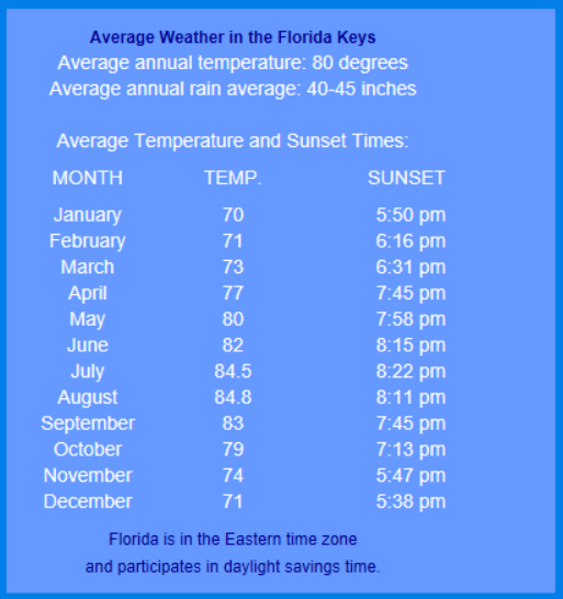
Florida Keys Average Temperatures
Travel and Explore The Florida Keys and Key West
• Visit Ramrod Key
• Visit the Torch Keys
• Visit Big Pine Key
• Visit No Name Key
• Visit Summerland Key
The Florida Keys are an outdoor play land with 4 National Wildlife Refuges on land and water and a National Marine Sanctuary that surrounds the islands on both the Atlantic and Gulf, making the Keys one of the most pristine places in the Continental US for viewing wildlife on land or on the water. Fishing, diving, boating, and sailing can be enjoyed almost every day. And don't forget our Keys sunrises and sunsets; one is more spectacular than the other. And if it's Key West night life and culture you are looking for, Key West has some of the finest restaurants, night clubs and music venues to finish off your day.
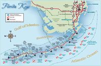
The Lower Florida Keys
Click to open in Google Maps.
The Keys are divided into three area's Upper, Middle, and the Lower Keys. The Upper Keys begin just below Biscayne Bay however the Florida Keys experience for many begins on the drive down the 18 Mile Stretch. An area of transitional wetlands where the The Florida Everglades, Florida Bay, and the Atlantic Ocean meet. The 18 Mile Stretch is one of two roads that connects mainland Florida with the Florida Keys. The other is Card Sound Road a little longer and slower trip that also has a toll bridge on it.
Once through the stretch, you enter Key Largo, MM (mile marker) 107.2. The proximity to the Mainland makes Key Largo, Tavernier, Islamorada, and Upper and Lower Matecumbe, a popular weekend destination for many from the mainland. It also affords residents a short drive and to put it as locals do, "get off the rock".
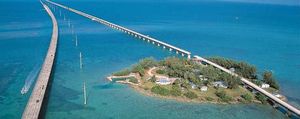
The Florida Keys Seven Mile Bridge
separates the Middle Keys from the Lower Keys
Buyers' Tools
Florida Keys Utility Companies
Florida Keys Electric Cooperative serving Key Largo, Tavernier, Plantation Key. Windley Key, Upper and Lower Matecumbe, Long Key, Duck Key, Grassy Key and Marathon.
Keys Energy Services serving Big Pine, Big Torch, Little Torch, Middle Torch Key, Ram Rod Key, Summerland Key, Sugar Loaf Key, Saddle Bunch Keys, Big Coppit Key, Stock Island, Bocca Chica Key and Key West.
Key Aqueduct Authority serves all for the Florida Key for water service.
Monroe County
Florida Keys School District
ROGO and Building Permits
Layman's Guide to Florida Keys ROGO Florida Keys Rate of Growth Ordinance explained. (PDF file)
Layman's Gukde to Big Pine Key ROGO Big Pine Key Rate of Growth Ordinance explained. (PDF file)
Boating and Recreation
Financing
Home Owning Calculators


